
14 March 09, I arrived at Taoyuan International Airport at 2.20pm. My hiking friends were in Taipei a day earlier than me. I was told to meet them up at Taipei train station. So, I took the GuoKuang bus (国光客运) to Taipei Train Station (台北车站). Bus fare from Taoyuan Airport to Taipei Train Station is NTB 125. The bus is operated at 15-20 min frequency. The bus journey took

about 50 minutes. After I met up with Hai Poh, Man Tack, Ai Yen and Wan Ming at Taipei train station, we took the train(自强号) to YiLan(宜兰). At there, I met up with the rest of the friends which arrived earlier at YiLan. There were 11 of us that would be joining Mt Nanhu hiking trip. We stayed at Yilan Youth Hostel (宜兰救国团学苑).
15 March 09, we met up with our

trekking guide - Lim Wen Yi. He is already 50 years old, but looks younger than his age. He told us that we can call his nickname "YaZi"(鸭子) . Trekking permit of Mt Nanhu had been applied couple of months before with the help of a Taiwan friend - ChunChun (纯纯). 7.00am, we took bus from YiLan to SiYuanYaKou(思源埡口), the entrance of Mt Nanhu trekking trail. The bus journey was about 2 hours.

A week ago, it was snowing in the mountain. We waited at the entrance for other trekkers to come out to find out the snow situation in the mountain. Around 9.30am, we met some trekkers that came out from mountain. They told us there was still some snow left in the mountain but equipment like ice axe and crampons are not required. We were so glad to hear that as we could offload some weights. We started on the trek around 10.30am. It was 6.7km trek to reach the real starting point of Mt Nanhu trek. It took me 2.5 hours to reach this real starting point. To reach our destination of the day - YunLing Cabin (云稜山

庄) at 2580m, it's another 5km trek. You may think that the total 11.7km is short, but when carrying the heavy backpack and trek on the trail that consists of ascents and descents, the journey became very long (at least for me). For guys, their backpack were even heavier as they have to carry the all the foods. When we reached YunLing Cabin, it's already 5.15pm.

This mountain hut is new and nicely built. I heard there is an old mountain hut that located not far away. There is a water tank that filled with rain water. Trekkers will use the water from the tank for cooking and drinking. To keep the hut clean, trekkers are prohibited from leaving the garbage including the leftover food at the hut. There are 2 toilets not far away from the hut. One is built nicely with the door, but it's very smelly. Another one is open toilet which there is no door/wall, but it's less smelly.

16 March 09, Wan Ming falls sick yesterday. He rest at YunLing Cabin whereas 10 of us continue our journey to Nanhu Cabin at 8am. After 2.5 hours trekking, we had slowly left the forest behind and ShenMaZhen grassland (审马阵草原) came into sight. The weather was good. Clear blue sky and beautiful mountains scenery. About 11.30am, we had made it to summit of Mt ShenMaZhen (审马阵山) at 3141m. We spent about half an hour resting and taking photographs before continue our journey under the hot sun. We passed by ShenMaZhen mountain hut(审马阵山屋) and moving uphill. There is a pond beside the ShenMaZhen mountain hut. I went down to the pond and tried to shoot some pictures of Mt

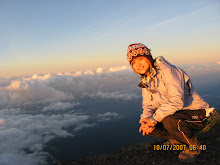
Nanhu reflection but I was not successful. We reached at a junction, took the left trail and lead up to the north peak of Mt Nanhu. Mt Nanhu North Peak or NanhuBeiShan(南湖北山) at 3535m is one of the hundreds highest mountains in Taiwan (台湾百岳) . It offered 360-degree paranoma view, Mt Snow(雪山) ,Mt DaBaJian(大坝尖山) , Mt ZhongYangJian (中央尖山), ShengLinXian (圣陵线) or Holy Ridge can be clearly seen. It's windy at north peak. I felt very cold after awhile, quickly descended after took some pictures.

It was about 2.30pm when we left Mt Nanhu North Peak and moving towards WuYanFeng (五岩峰) or Five Rocky Peaks. As it named, there are 5 hills that we need to climb over. Both side of the path are the steep valley. I think WuYanFeng trail should be the most dangerous part of Mt Nanhu trekking, especially if there is snow or strong wind.

The ascents and descents seem like never ending. I was very tired. 3.45pm, I had climbed up the 5th hills, saw a signboard indicate that Nanhu Cabin(南湖山庄) is 1km away. I can see the mountain hut down the deep slope. I thought I should be able to reach there very soon but I was wrong. The path down is more difficult than I thought. Slowly and carefully, I descended on the steep loose rocky slope. The cold wind blow strongly. Stress had been put on my knees and I started to felt pain. I was very cold and tiring, wondering why the 1km route was so far away. Finally, at 5.15pm, I checked in Nanhu Cabin.

Nanhu Cabin was located at the lower cirque glacier of Mt Nanhu (南湖下圈谷). At that day, it was fully occupied by 3 hiking teams including us. One of the team was the HuaLian(花莲) police team. The policeman is a nice guy. He gave us advice on our tour itinerary and offered his help if we plan to be in HuaLian. When we were at HuaLian 5 days later to take the train back to Taipei, he met us at the train station and bought us some local foods. All we can do is only say "thanks".

17 March 09, we started our trekking to Mt Nanhu main peak (南湖主峰) around 6.30am. Our guide purposely brought us to the trail that still has snow. Step by step, we were approaching Mt Nanhu main peak. 9.00am, I had reached the summit of Mt Nanhu main peak. There is a marker of 22.9km at the summit, indicate that we had trekked 22.9km to reach

the peak at 3742m above sea level. We are busy photographing with different jumping pose. Mt Nanhu East Peak can be seen here. That's our next destination.
40 minutes later, we left Mt Nanhu main peak, heading towards the East Peak. Just before we reached the mountain foot of East Peak, Peng Meng found that he lost his camera. He suspect

that he must be left it at the first resting point after we went down from the main peak. So, he went back to search for his camera while the rest of us wait for him there. Under the hot sun, we had waited for almost 1.5 hours. This place is shadeless. We felt the strong UV, at the same time, felt the cold air. That's why I had to wear the jacket, at the same time kept on apply the sun block. Peng Meng came back around 12.oopm, without his camera. He told us that he couldn't find it. He will follow us to hike up the East Peak, then go back once again to search the camera.

The summit of Mt Nanhu East Peak(南湖东峰) is different from the main peak. The summit of east peak is at the slope. The highest point of the slope stands a monument denotes an elevation of 3632m above sea level. Unlike at the main peak, we couldn't took the photos with the jumping pose. It will be too dangerous to do that. However, the rock formation at the east peak is very unique and pretty. After we

descended from the summit, Peng Meng and our guide went to search for the camera while the rest of us follow the trail from the upper circque glacier back to the Nanhu Cabin at lower circque glacier. I back to Nanhu Cabin around 2.15pm. Surprisingly, we saw Wan Ming's belongings at the Nanhu Cabin. So we knew that he had recovered and probably on his way up to the main peak.

Not bad, he recovered in 1 day and then able to cope with the journey. No wonder Hai Poh will say "he is as strong as an eagle". hehehe....:p
Finally, Peng Meng came back, with his camera on his hand. We were teasing him that he's the one that gain most from this trip - paid guide fee for 1 time, but went up to summit for 3 times, really worth for value. ;)

18 March 09, we were leaving Nanhu Cabin at 8.00am. Once again, we were on the steep rocky slope that rises up to the WuYanFeng(五岩峰). Bit by bit, step by step, we climbed up the slope. Suprisingly, all of us had climbed up the slope within 35 minutes. On this particular trail, ascent is actually easier than descent. We followed the same route, climbed up the five rocky peaks of WuYangFeng, reached the junction to Mt Nanhu North Peak. Our trekking pace became faster, we reached YunLing Cabin at 1.30pm. We rest and refill the water at YunLing Cabin before continue our journey to DuoJiaTun (多加屯) . Around 5pm, we reached DuoJiaTun.

The mountain hut of DuoJiaTun is very small, can only fit in 6 persons. Man Tack and Wan Ying helped to clean the dirty floor. DuoJiaTun is at 2795m. It's still very cold at night. 11 of us need to fit ourselves inside this mountain hut to spend the night. Each of us can only lie down in 1 pose and not able to move. I only slept for 2 hours and couldn't sleep again after that. I kept on watching my watch, counting down the time for the sunrise. At that time, I felt that the time was crawling like snails. I was so glad that finally it's 5am, time to wake up.

19 March 09, we packed our things and left DuoJiaTun around 6.30am. We had to rush for the bus at 9.30am, thus there was no time for us to take the leisure walk. By 9am, we had reached SiYuanYaKou, marked the completion of the Mt Nanhu hiking trip.
Below is our hiking route:
SiYuanYaKou,1930m (思源埡口) -> Main Entrance, 2300m(登山口) -> YunLing Cabin, 2580m(云稜山庄) -> Mt ShenMaZhen, 3141m(审马阵山) -> Mt Nanhu North Peak,3535m (南湖北山) -> Nanhu Cabin, 3592m (南湖山庄) -> Mt Nanhu Main Peak, 3742m(南湖主峰)-> Mt Nanhu East Peak, 3632m(南湖东峰)-> TuoJiaTun,2795m (多加屯) -> SiYuanYaKou(思源埡口).

Other Info:
1) In taiwan, trekking permit has to be applied at least 3 weeks in advance. With the trekking permit that obtained from national park, go to the police station to apply for the mountain entrance permit. For Mt Nanhu trekking permit application, refer to the website
http://permits2.taroko.gov.tw/welcome/index.aspx.
2) For train info, refer
http://www.railway.gov.tw/index/index.aspx3) Yilan Youth Hostel (宜兰救国团学苑), refer
http://tw.myblog.yahoo.com/yilanstudenthostel4) To reach SiYuanYaKou (思源埡口), take the GuoGuang bus (国光客运) of route Yilan(宜兰)-LiShan(梨山), take off from Yilan at 7am and 12.40pm daily.
For bus info, refer to
http://www.kingbus.com.tw/time&price.php
 19 March 09. 离开南湖大山后,我们乘搭公车从思源垭口往梨山。途中经过武陵农场及奇莱山登山口。南湖的向导-文逸曾经说过,奇莱山是台湾百岳中最险峻和难爬的一座山。那里曾经发生几次山难,因而流传不少灵异故事。我在巴士上睡着了,睁开眼睛时已抵达梨山。梨山种满了梨树。三月正是开花的季节,光秃秃的梨树开满了白色及粉红色的花,很漂亮。路边的小贩卖的梨子很大一粒,我与Irene买了一粒40元的梨子,要求老板娘去皮切好。梨子一咬在口里,清甜的果汁充满整个口腔,多汁又爽口,好好吃哦!我们在梨山包租了一辆车子到合欢山。司机名叫雷洛,我想我应该可以用面恶心善来形容他吧。他的样子看起来像流氓,但脸上却总是挂着亲切的笑容,一路上还热心地给了我们中肯的旅游建议。当天,我们下榻于合欢山庄。合欢山庄有提供通铺,每人580元,包括一个早餐和晚餐。浴室是公用的,有热水供
 应。我冲了个热水澡,小休了片刻。大约下午4点,又是时候往合欢东峰出发了。从合欢山庄步行至东峰起点只需10分钟。起点旁的松雪楼正在装修。合欢东峰长满了箭竹,从远处望来,犹如一片辽阔的草原。登山步道虽然有点陡,却不难走。合欢东峰可以清楚的看见奇莱山,风景实在不赖。只是我早上刚从南湖大山下来,有些疲惫,又不太舒服,没有太多心思慢慢欣赏。山顶风很大很冷,我拍了照,待了一会儿,就开始下撤。其他队友也陆续下山。只有精力充沛的赖家三姐妹和海波留在山顶等待日落。回到合欢山庄,差不多是晚餐时间了。六点半,一桌子的菜肴已经准备好。对于吃了四天五谷米的我们,那晚餐简直可以用丰盛来形容了。我们不等海波和赖家姐妹,迫不及待开动了。天色已暗,我们那四位看日落的队友终回到山庄。晚上,温度应该介于8-10度吧。一整个星期都活在寒冷中,有点想念暖和的天气了。
 20 March 09
 当初我以为南湖之行结束后,我可以好好休息,恢复体力,因为我还有玉山之行呢。怎知道南湖大山后,就紧接合欢东峰,然后又是合欢主峰,还真的有点累。尽管如此,我还是跟随队友们的脚步,缓延而上。天色微亮,大约6时,我们抵达山顶。按照我们在马来西亚看日出的惯例,日出应该是天空会开始出现一片橙色,渐渐的橙红色的太阳会慢慢升起,然后才天亮。可是台湾不太一样,天空亮了,还不见太阳升起。我们都以为没日出可看了。突然,大伙儿喊了起来。犹如红鸡蛋的太阳出现了,徐徐升高,直至绽放耀眼光芒。在阳光的照耀下,合欢主峰披上了一件金色的外衣,山峦起伏,景色很是迷人。
 离开合欢主峰,我们回到合欢山庄收拾行李,往下一站目的地-天祥,出发。一个星期以来,我们平均都在2000-3000公尺的地方活动,这天终于来到位于太鲁阁国家公园内,海拔450公尺的天祥,顿时觉得好暖和。我们入住天祥救国团青年活动中心。这里消费不便宜,五人房,每人收费700元,包括一个晚餐及早餐。不过这里有投币洗衣机和烘干机,正好让我们把几天来的脏衣物通通洗净烘干。抵达天祥救国团青年活动中心时不过是上午时分,我们还不能登记入住。于是到附近闲逛。我们在天祥的邮局里买纪念邮册,寄明信片,消磨了不少时间。然后到附近的祥德寺参观。下午,我们依着旅游手册到白杨步道去。由天祥往台中方向走约900公尺,过了明隧道,就看见公路左边有一隧道,这就是白杨步道入口处了。白杨步道是一段长达3.3公里的行人步道,可以抵达白杨瀑布,而步道的尽头就是水濂洞。途
 中经过好几段隧道,必须自备手电筒照明。一路上都设有告示牌 “注意落石” ,却被我们开玩笑成 “注意落后”。水帘洞还蛮好玩的。我把鞋脱了,穿了雨衣,沿着水道走入洞里。洞里很凉快,水从洞的上方流下,形成水濂。游客可以选择走在水道旁的小道,避免成为落汤鸡。我们起了童心,偏选择走水道,在水濂与水濂之间的缝隙穿梭,当然,我们被淋湿了,却玩得很开心。
 21 March 09
 过。他原名苏万民,却被海波改名换姓成“车晚鸣”。我是通过海波认识万民的,所以跟着海波叫他车兄。庆幸有车兄在,我才免了在夜里找地方住的彷徨。


