Tuesday, December 30, 2008

环绕安那普那(Annapurna Circuit)徒步行 (11-31 Oct 2008) - Part 2

18 Oct 2008 (Saturday) - Pisang (3200m) -> Manang (3540m)
向导告诉我们共有两条不同的路通往Manang,一段较长,需时7-8小时,另一段则较短,需时5-6个小时,风景各异。我其实还蛮想走那一段较长的路,只是队友们不太感兴趣。投票结果,我们选了较短的路徒步至Manang 。离开Manang,步行大约一小时,我们来到了一个观景点,可远眺Humde村镇景色。Humde有个小型飞机场,有来回Pokhara的班机。

这天,我们悠闲得很。除了早上的一段斜坡路外,大部份时间我们都是走在宽阔平缓的道路上。开始闻到秋天的味道了。松叶转黄,红色不知名的植物点缀着大地,Pisang雪峰展现着它那漂亮的容颜,我放慢脚步,轻松惬意地欣赏美不胜收的景色。走着走着,路延伸到了河边,沿着河岸走,就到了Braga村镇。眼前突然一亮,多年前在山友炳明放的幻灯片里看见的“龙门客栈” 现在就在眼前。它处在山坡上,依山而建,我匆匆地在山坡下扑捉它的身影。我吃完午餐后,趁着队友们还在用餐,独自一个人走到山坡上去拍照。风挺大的,可我好想近距离的看看那独特的民宅,所以快步向它走去。我站在山坡上,凝视着那一层层依着山壁而建的石板屋,往山坡下望,青黄色的草地,金色的黄土坡,远处的雪山,拼凑出让人心醉的美丽。在最高处有一间庙,我本想走上去看看,但又怕朋友们在等我,所以拍了一些照片后,就不舍的回到餐厅去。

从Braga 到Manang,只需30分钟的行程。我们在下午3点就到达Manang了。我把一些衣物给洗了。洗衣服可真是一件折磨的事。冷水在10秒内就把我的手冻得发麻。我一边喊着“好冷,好冷” ,一边快手快脚的把衣物随便洗洗,拿去晾干。我们住的旅舍叫Hotel Mountain Lake。据说,这家旅舍的老板是个日本人,爱好摄影。墙壁上挂了不少他的作品,其中有一张雪豹的照片还曾经获奖。旅舍的餐厅分为两个区,一边有暖炉,另一边没有。暖炉区虽暖和,但却因为燃烧而使氧气缺少,长时间吸入一氧化炭也会使身体不舒服,进而演变成高山症。所以即使寒冷,海波坚持要大家坐在非暖炉区,避免缺氧。这天剩下的时间都是在这餐厅里度过。

19 Oct 2008 (Sunday) - Acclimatization Day at Manang (3540m)
这天,我们依然逗留在Manang作海拔适应。早上9点,我们到附近的小山走走。Irene有些不舒服,Dee陪着她,她俩没有随行。虽说是小山,但路线非常陡斜,上升400m,不是散散步就可以轻松到达的。半山腰,可以看见Gangapurna湖。山顶上,几乎每人都要拍一张以Gangapurna雪山为背景的照片。Manang全景一览无遗,整个村镇都是土色系的,与大地容为一体。这段行程耗时3个小时,回到旅舍时已是12时许了。下午3点,我们去听一个免费讲座。那是一个由自愿医生组成的团体所给的讲座,讲解高山反应症状,如何避免及应对措施。听完讲座后,我们也顺便测试血液中的含氧量,指数不错,含氧量充足。到目前为止,我们每一个人都可以适应高山海拔。明天,我们将出发到4000公尺的Yak Kharka,离Thorong La Pass又靠近了一步。


20 Oct 2008 (Monday) - Manang (3540m) -> Yak Kharka (4050m)
从Manang到Yak Kharka,只需5个小时。因为途中没有适合的午餐地点,我们是到了Yak Kharka才吃午餐的。在旅舍的餐厅里,我们点了午餐,正等着食物上桌。即使是在室内,即使外头阳光耀眼,我们还是觉得很冷。而与我们同桌的一个俄罗斯人竟然只穿短袖T-shirt和短裤。我们好奇的问他:“不冷吗?” 。他不会说英语,但态度很友善,一直用俄罗斯语回答。我们比手划脚地与他沟通起来。他告诉我们他一点都不冷,他还曾经试过冬泳,了不起。

午餐后,有些登山客会到旅舍不远的山坡上作海拔适应。适应高海拔的黄金定律是“爬得高,睡得底” 。登山客都会徒步至较高的地方,然后再回到低一点的地方住宿。与其到山坡上去,海波,Dee,永刚和我到了Churi Ledar买净水,其他队友留在餐厅休息。原以为Churi Ledar离Yak Kharka很近,怎知估计错误,来回用了一个多小时,再次回到住宿点时已是3.45pm了。回程中,风吹得我头好痛。过去的四天,每到中午必起风,在这样的海拔被风吹可不是好玩的。

晚上,我在餐厅写日记。同时,我也一直喝水,然后上厕所。这是让身体适应海拔的措施之一。明天将上升至4800公尺,是我们行程中最高的住宿点,是决定能不能过ThorongLa Pass关键性的一天。

21 Oct 2008 (Tuesday) - Yak Kharka (4050m) -> High Camp (4800m)
每天出发前,我们都会拍一张团体照。在Yak Kharka的团体照里,我们每一个人都变成了“蒙面忍者” ,全身包得只露出眼睛。即使这样,我的牙齿还是一直在打架。叶子结了霜,昨天还流动的小溪或水道也结冰了。我们得小心翼翼地垮过,一不小心就会滑倒。到High Camp前,我们先到达Phedi (4200m) 。其实有很多登山客选择在Phedi住宿,减低高山症的风险。在Phedi,我们又遇到了Morgan,一位来自Slovenia的登山客。打从Syange开始,我们不时会在徒步行程中碰见他,所以认识。Morgan非常友善与健谈。他独自一个人旅行,在途中不断结识朋友,自由也不寂寞。

我们在Phedi用完午餐后,就开始出发往High Camp了。望着那急剧升高的斜坡,我告诉自己“别想太多,慢慢走,一步一步走,要不停的走”。陡坡路一直延伸,不知何时才会到目的地。走了好长的陡坡路,我看见海波,永刚和凤凤在一块大石头前停下。那里有一小段的梯级,正好可以坐下休息。我也停下来小休片刻。High Camp已近在咫尺了。风让我冷得有点受不了,所以没停留多久,脚步又开始慢慢往上移。海波也跟上来。永刚和凤凤则多继续停留。明明是短短的一段路却好像特别远,我像乌龟一样慢慢的爬上去,终于在大约下午2点到达High Camp了。

我们的房间面向来时路,可以清楚地看见登山客一步步往斜坡上爬。几个熟悉的身影开始显现,只是情况有点不对劲。永刚被几个队友扶着,走三步停两步,很吃力的爬上来。我心想“:不妙,是高山症!” 。永刚一路上来的状态不错,万万没想到竟然是他被袭倒。好不容易,他终于到达了。他面呈紫色,嘴唇发白,脚步飘浮不稳。他说他的头痛得很,没胃口,给他的蒜头汤只喝了一点。他休息了好一会儿却丝毫不见好转,于是当机立断下撤至Phedi。我们目送永刚被背夫Nima扶着离开High Camp。我们都希望他休息一晚后可以好起来,明天从新归队。

在4800公尺的海拔,大家的胃口都不好。热腾腾的食物刚端上桌,没多久就冷得像隔了夜的饭菜一样。餐厅里没有暖气,我们紧靠着彼此坐在一起来抵御寒冷。厕所在外头,上厕所是痛苦的,连厕所里盛水桶里的水都结了冰。鼻子不断流鼻水,喉咙也因为寒冷和干燥而不停咳嗽。这些状况已是预料之中,所以不担心。关于Thorong La Pass,我没有想太多,但我已准备好。

22 Oct 2008 (Wednesday) - High Camp (4800m) -> Thorong La Pass (5416m) -> Muktinah (3800m)

凌晨3点30分,我们就起床了。收拾好行囊后,我们就到餐厅吃昨天就预先点好的早餐。踏出房门时,我呆住了。三面的雪山在夜里白得发亮,闪烁的星星布满整片天空,月亮露出半边脸静静地看着大地。突然,一颗流星划过天际。我匆忙的许下愿望,希望我们的旅程能顺顺利利。我真的很想站久一些,看这梦幻美景多一眼,可我却冷得直发抖,于是快步地往餐厅走去。那天的早餐非常难吃。三文治面包又冷又硬。我逼自己无论如何一定要吃下去,因为我需要能量。当我们还在用早餐时,前两天遇见的六个年龄将近半百的丹麦人已从Phedi到了High Camp。他们精神抖擞的跟我们打招呼:“Good Morning Malaysians",回想起昨天我到High Camp时的累模样,自叹不如。

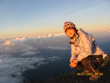
我们大约在5点30分往Thorong La Pass出发。海波的温度计显示当时是零下7度。天还未亮,我们靠着头灯一步步往陡坡上走。山坡上都是积雪,唯独徒步的小道一点雪也没有。我好奇地用脚踢了踢那些积雪,是硬的。虽然冷得要命,可心里却有种莫名的兴奋。走了差不多一小时,我们到了一个休息站。这里有间小木屋。我并没有停留超过5分钟,因为太冷了,必须走动才可以让身体有热能。我后来一直跟Dee一起走。我们都因为那美丽的雪景而兴奋不已,虽然很冷,我还是不断地停下,用我那冻僵的手指颤抖地按下快门,将那一刻的美丽收藏起来。我和Dee在8时许到达Thorong La Pass最高点(5416m) 。海波递了两杯热茶给我们。热茶从哪儿来?原来这里还是有一间小木屋,有人售卖热茶,生意好得不得了。海波说温度是零下10度。瓶子里的饮水都结冰了。可是寒冷完全没有影响我的心情,我还觉得有点遗憾,雪如果再多一点,一定会更漂亮。队友们在过了一阵子后陆续到达。海波有轻微的高山反应,所有他不断催促我们拍团体照,然后就逃亡似的下撤。Dee在后跟随着海波,我舍不得这么快走,多留了一会儿。

我们将下撤1600公尺,山路之斜可想而知。一路往下,我还可以看见棉花形状般的白雪。路就这样一直倾斜至Muktinah。下午1时许,我们就到达Muktinah了。Muktinah处于3800公尺的高度,在山区里应该可以称为市镇了。这里有一所规模不小的寺庙,有很多当地的信徒特地来朝拜。但是我们并没有去参观,大概是我们都累了吧,只想快点到旅舍休息。

关于永刚,有登山客带来了他的消息。永刚的状况没有好转,所以他将在Phedi多休息一天。明天他会过Pass,后天将乘坐吉普车来追上我们。而我们则照着原订的行程一站一站地走下去。

Monday, December 15, 2008

环绕安那普那(Annapurna Circuit)徒步行 (11-31 Oct 2008) - Part 1

11 Oct 2008 (Saturday) - KLIA -> Kathmandu
当地时间10am, 我再一次踏进了加德满都的红砖墙机场。第二次造访,我少了两年前的兴奋,取而代之的是一种熟悉又陌生的微妙感觉。往Thamel途中,我温习着记忆中的片段,那红砖建筑物,有点混乱的交通状况,载着一篮子苹果的脚车水果贩等景象一一映入眼帘,原来两年光阴并没有为这尼泊尔的首都带来什么具体的变化。

这一次同行的山友有秀娟(小名:Dee) ,海波,德龙,雪琴(德龙的未婚妻) ,凤凤,永刚和 Irene。当天,我们下榻于Khangsar Hotel。红宝石旅行社的老板-李建替我们安排前往Dumre的巴士车票及在Dumre接恰我们的登山向导与背夫。李建是个说得一口流利华语的尼泊尔人。德龙说当初联络李建时,他答应作我们的登山向导,不知怎么的,碰面时却成了为我们安排其他向导的中间人。

Expenses
Visa for 30 days - USD 40
Khangsar Hotel - USD 5 per person
Lunch at Momotarou Restaurant (桃太郎) - Rp 180 (RM 7.50)


12 Oct 2008 (Sunday) - Kathmandu (1300m) -> Dumre (420m) -> Besisahar (793m) -> Bhulbhule (840m)
早晨,我们背着行囊随着旅行社接洽人穿越Thamel的小巷来到了巴士站,搭上了7.00am前往Dumre的巴士。巴士的座位很窄,行李全被绑在车顶上,车上坐满了前往Pokhara 和Dumre的外国旅客。5个小时后,我们到了Dumre,见到了我们的登山向导- Miran和背夫们。然后,我们就一直被向导催促以包车的方式前往Besisahar,路程是一个小时半。在匆促决定下,我们付了Rp 3500 (RM 175),包了一辆吉普车到Besisahar,足足多付了一倍的车资。这件事让我们对这初次见面的登山向导印象大打折扣。

由于昨天是尼泊尔的公共假期,我们来不及在加德满都办登山证。经过一番讨论,虽然费用是在Pokhara 或Kathmandu办的双倍,大家还是决定直接在Bhulbhule办登山证以节省时间与不必要的麻烦。我们花了Rp1500 (RM75) 包了吉普车从Besisahar 到Bhulbhule,赶在天黑前办好入山证。

当晚,我们就在Bhulbhule住宿。为期17天的环绕安那普那徒步行正式掀开序幕。

Expenses
Bus from Kathmandu to Dumre - Rp 450 (RM22.50) per person
Jeep from Dumre to Besisahar - Rp 3500 for 13 persons (8 of us + porters & guide)
Jeep from Besisahar to Bhulbhune - Rp 1500 for 13 persons
Trekking permit - Rp 4000 (RM 200) per person


13 Oct 2008 (Monday) - Bhulbhule (840m) -> Syange (1130m)
Bhulbhule处于海拔840m,比加德满都还低,温度就如云顶高原般凉快。早晨8时,我们离开Bhulbhule往Bahundanda(1310m)。一路上伴随我们的是那青黄色的稻田风光。Bahundanda原本是我们行程中住宿的地点,但到达时是中午,所以在午餐后,我们继续往下个地点-Syange(1130m)出发。下午三点半,我们在一所建在Marsyandi河边的茶屋(Tea-house) 停下脚步,结束这一天的行程。

茶屋不远处有壮观的瀑布,河的对岸也有其他的旅舍。两岸由一座吊桥衔接着。这所茶屋是由一对夫妻经营的,只有几个房间,虽然简陋,但老板非常亲切。这位年轻的老板学过马来语,所以我们除了英语外,还可以用马来语跟他沟通。这天,我们是他的唯一客户,所以招待周到。夜晚,海波开始发表他的经济学理论。渐渐的,大家悃了。就这样地,我们在隆隆流水声的陪伴下进入梦乡。

14 Oct 2008 (Tuesday) - Syange(1130m) -> Tal (1700m)
早晨8点离开Syange,沿着河缓缓向上,一个小时半后我们到达Jagat。这儿有一所很小的学校,有几位学生非常合作的排好让我们拍照。午餐地点定在Chamje,所以我们继续往上走。在Annapurna地区,人们让马或驴子运送货物。我们徒步时常得让路给驴群,同时也要小心闪躲路上的驴粪。和昨天一样,天气晴朗,艳阳高挂,我热得汗流浃背,真的有点受不了。我除了猛擦防晒油之外,还用小毛巾盖着头,遮着脸。这里跟两年前的寒冷EBC(Everest Base Camp)徒步很不一样。大约11.15am,我们停在Chamje,坐在一间餐厅二楼的走廊用午餐。祭了五脏庙后,我们又开始徒步在不间断的上坡路上。河谷风光非常秀丽,就这样地,我们来到了Tal ,一个坐落在河边的美丽村子。在Tal,河神显得特别安祥,浅青带蓝白的河水静静躺着,与来到Tal前的汹涌有天渊之别。

茶屋的名字叫 Hotel Dragon,两层楼,房间还不赖,比昨天的好多了。Tal有个净水供应站,每公升净水售价Rp35 (RM1.75) 。而旅舍的一壶热水 (3公升)是Rp200 (RM10) 。矿泉水一瓶则是Rp80 (RM4) 。净水供应站为我们省下了不少买饮水的钱。德龙在地图上圈起了有净水供应站的村庄,作为补充饮水及住宿的地点参考。

当天晚上,我的喉咙开始痛,觉得头微微发热,心里暗忖:糟了,要生病了。我还有15天的徒步行程啊,怎么办?

15 Oct 2008 (Wednesday) - Tal (1700m) -> Danaque (2200m)
早上天晴,下午下了一阵小雨。我们在大约8时离开了美丽的Tal,前往下一个目的地 - Danaque。瀑布在Annapurna Circuit是处处可见的。我数不清一路上到底看见了多少瀑布。9.30am, 我们到达Korto,10.20am,我们到达Karte。40分钟后,我们就来到了Dharapani。Dharapani有个通行检查站,必须出示登山证方可通行。向导在我们到达前已办好检查手续,所以我们没有停下,继续往前走。从Dharapani往Bagarchap的路,我开始觉得吃力了。可能身体不舒服的关系吧,我没有心情拍照,只想快点到达目的地。大约中午12点,我们到达Bagarchap,停下吃午餐。用餐后,我觉得昏昏欲睡。海波继续发表他的资本论,只是不晓得有谁在用心听。

1.30pm, 我们又开始徒步,半小时后就到达Danaque了,下榻于Himalayan Guesthouse。我的室友是Irene。我们的房间在楼上右边走廊的最尾端,三面都是玻璃窗,虽可看风景,但却比其他房间寒冷。没多久,天空飘起雨。我赶紧冲个凉,一头钻进睡袋里休息。头感觉热热的,喉咙很痛。我一直喝水,只希望不要真的病倒。睡睡醒醒,一直到晚餐时间,才到楼下的餐厅用餐。

16 Oct 2008 (Thursday) - Danaque (2200m) - Chame (2713m)

早上起床,我的喉咙痛没有好,但也没有变严重,谢天谢地。
一离开Danaque,我们就翻上了一座小山,上升550m。路一直都是斜斜向上的。我们经过松树林,来到了Temang。然后,路开始往下,经过了一个农村,过了一座吊桥,又开始往上爬了。斜坡上突然尘土飞扬,原来是有一大群山羊被赶下坡。我们只得让路,靠边站,让山羊群先过。大约11点,我们到达Thanchok 。小休片刻后,我们原打算再走45分钟到Koto用餐,却被路旁的苹果园吸引而停驻。走进了苹果园,买了苹果当开胃菜,索性就在苹果园主人的餐厅吃午餐。

我们在大约2.15pm到达Koto。这里的房子很古色古香。通行检查的手续办妥后,我们再步行30分钟就到达Chame,住进了Sunrise Hotel。Chame是个不小的村庄。我们到处逛逛。有个指示牌上写着 "Hot Springs",我们随着它到温泉看一看,结果让人大失所望。那所谓的温泉只是在河边的一小滩水,顶多能洗洗手。6点,我们回到旅舍准备用晚餐。晚餐后,我一如前几天一样,看看书,写写日记,直到悃了才休息去。

17 Oct 2008 (Friday) - Chame (2713m) -> Pisang (3200m)

一如既往,我们在8点钟起程。空气转凉,毕竟已接近3000m的海拔了。斜坡缓缓向上,经过荞麦田,然后是一连串的上坡与下坡,这就是离开Chame后的路况。Lamjung Himal 和Annapurna II雪山逐渐清晰。来到Bhratang,路旁有苹果园和荒废了的石屋。大家休息了一会儿又继续前进。我走进了松林,有点累,好不容易走到了Dhukur ,停下吃午餐。我点了Dal-Bhat ,那是道地的尼泊尔食物。Dal-Bhat其实是Dal豆汁捞白饭配炒菜,腌菜与马铃薯,非常有利于补充能量。更妙的是若吃完了还可以要求补上,所以绝对吃到饱。填饱了肚子以后,我感觉好多了。午餐后,再走个40分钟,我们就看见Pisang村庄了。Pisang分为Upper Pisang 和Lower Pisang。我们住在Lower Pisang里位置最高的旅舍, 远远可看见建在山坡上Upper Pisang的房子,风景很漂亮。Pisang Peak清晰可见,非常抢眼。这里风很大,冷得我们不想到外边走动。夜晚,温度降到了摄氏1度。从这里,我才开始投入这次的徒步行,仿佛找回了EBC徒步行时的兴奋。

Thursday, September 25, 2008

Mt Batu Putih (30 Aug - 1 Sep 08)

I spent my National day holidays at Mt. Batu Putih (白岩峰), the 8th highest mountain in Peninsular Malaysia, with another 14 friends. We sang the national song, shouted excitedly when we saw the rainbow clouds at the summit. It was the stary night. I saw a meteor but not able to make the wish in time. :p That's the rewards for spending the 2 days time to hike up 2131m above sea level.

29 Aug after work, we drove to Tapah and spent overnight there. 30 Aug early morning, we proceed to Kuala Woh. After passed through the Kuala Woh dam, we reached the aboriginal village. That's the starting point of our trek. We were on the trail along the riverbank for about 45 minutes, then it led to a bamboo bridge that helped us for the river crossing.
The trail was getting steep after that. Hai Poh chose to camp at The Cave because there is water stream nearby. The Cave is not the real cave. It is the campsite that shaded by a big rock. I reached The Cave at 5.30pm, after 7.5 hours hike. Actually, Lai, Hai Poh, Liow, Tack and I should be able to reach earlier. But we had missed the junction that lead to The Cave, almost reached the botak hill campsite. I had spent 1.5 hours to make this U-turn.


31 Aug around 10.20am, we continue our hike to the summit. About 1.5 hours later, we reached the botak hill campsite where a white vertical rock face came into sight. Out of my expectation, I reached the summit around 3.15pm. Besides us, there were another 2 groups of hikers there. The peak of Mt Batu Putih was bustling with noise and excitement at national day 2008.

Tuesday, July 29, 2008

Mt Semeru - Mt Bromo - Kawah Ijen( 2-7 July 08)

The triggering point of this trip is the photos that we saw at Kok Yuen's house when we visited him during Chinese New Year early of this year. Kok Yuen showed us the photos that taken by one of his friend and suggested about the trip. After the Chinese New Year, Airasia was having promotion. So, we took the opportunity to book the flight to Surabaya.

2 July 2008 LCCT - Surabaya - Tumpang
9 of us took the 10.15am flight and reached Surabaya by 11.55am (local time). Local time is one hour earlier than Malaysia. The agent picked us up from Juanda airport. We had lunch at one of the restaurant while settled the payment with the agent. Surabaya is the 2nd largest city in Indonesia with over 3 million of people. For us, it's just the gateway for Mt Semeru and Mt Bromo. After lunch, we started our journey to Tumpang and stayed overnight there. Although Tumpang is only 600m above sea level, it reached 18 degree Celsius at night.

3 July 2008 - Tumpang - Ranupani Village - Ranukumbolo - Kalimati
We woke up at 5am (local time). After breakfast, we were transferred by 2 cars to Ranupani. It should take 1.5 hours to reach Ranupani village. However, one of the car broke down when started to drive on uphill road. So, all of us have to squeeze into 1 car for the rest of the journey. The scenery along the journey is beautiful. In average 15 minutes, we stopped the car to take the picture. Ranupani is the starting point of the trek. Vegetables farm are along the road. We were trekking uphill on the nicely built path on the 1st hour. Then, we moved into jungle trek and 1 hour later, the beautiful lake of Ranukumbolo came into sight. Another half an hour trek, we reached the campsite of Ranukumbolo. It's 1.30pm but the temperate was about 14 degree Celsius. The lunch that prepared for us are instant noodles, biscuits, tea, coffee and apples. We had the lunch beside the lake, like picnic. :D

There was another 2 hours walking from Ranukumbolo to Kalimati campsite where we stayed overnight. Mt Semeru is active volcano, stay 3676m above sea level. Small eruptions happen every 20-30 minutes. We will trek up Mt Semeru from North. We saw 2 mini eruptions on the way to Kalimati. Of course we wouldn't miss this opportunity to take some pictures. Seeing the smoky clouds spew out from the mountain, it's really a new experience for us. The wind at Kalimati campsite was very strong. It was 8 degree Celcius at night. 9 of us squeeze into a tent, playing cards while waiting the porters to prepare the dinner for us. Luckily our dinner is fried rice. If it's instant noodle again, I don't think we have energy to climb the mountain the next day. The sky was very clear that night. We went out from the tent after dinner to see the stars. After a short while, we were not able to stand the cold. So, everybody went back to tent and slept.

4 July 2008 - Kalimati - Mt Semeru Summit - Lava View Lodge
The day started with the trek to summit at 1.30am (local time). At first, we still trekked on the jungle trek. After Arcopodo campsite, soon we were stepping on the sandy ground. The most difficult and challenging part of the trek had begun. The route is very steep all the way to summit. As it's active volcano, most of time, there is no hand hold or foot hold that can help us to move up. With every step, I slid backwards in the sand. I stopped quite often to catch up my breath. But the rest time is short because the temperature is low, I have to keep on walking to stay warm.

The sky streaked with red and yellow, a sign the sun was about to rise. Although tired, I pushed hard to beat the sun to the summit. I am crawling up the volcano instead of trekking up. When I stepped onto the summit, I realized that it's a large flat ground. Wind is extremely strong. The strong wind moves the sand high into the air. I can hardly open my eyes. I saw our porters lay down and prayed. After the pray, the guide and porters came to shake hands with us and congrats each of us to have reach summit. The entire climb took us 4 hours. It was very cold at summit. The temperature is 3 degree Celsius with strong wind. We descended once the sun started to fill up the sky. I think we stayed less than half an hour at summit. We didn't really admire the scenery and enjoy the sunrise because the chill at summit is unbearable. The way down is easier, sliding down like skiing. While easier, a great deal of stress is put on the knees.

We back to Kalimati campsite around 8am-8.30am. After breakfast, we packed our things and leaving to Ranupani village.

5 July 2008 - Lava View Lodge - Mt Pananjakan - Mt Bromo
We arrived late at Lava View Lodge yesterday. Early morning before sunrise, we were on the 4 wheel drive again to Mt Pananjakan. Although it's a mountain, no trekking is required as the view point is only 10 minutes walk from the place that 4WD dropped us. Once went down from the car, we were surrounded by the people that trying to sell the warm hat, scarf or renting the jacket. The temperature is about 11 degree Celsius. This place is crowded with tourist because of its easy accessibility. Besides, the scenery it offered also made this place a famous view point. Just look at the photo above, don't you feel that it's as beautiful as drawings?

After Mt. Pananjakan, we went to Mt. Bromo to see the crater. There is a short distance from the dropping place of 4WD to the mountain foot of Bromo. Tourist can choose to ride on the horse to the mountain foot instead of walking. I don't know how much it cost because we choose to walk rather than ride on the horse. I never been to desert before but I had a feeling that I was in the desert. I covered my face with cloth, but still cannot prevent the dust and the sand went into my eyes. We climbed up the staircase to visit the crater of Mt. Bromo. The smell of the sulphur is very strong. After took some pictures, I quickly went down from Mt Bromo to run away from the smell.

We were then back to Lava View Lodge. After breakfast, we packed our things and proceed to our next destination - Ijen, which is 6 hours away from Mt Bromo. We spent the night at Catimor Homestay - a lodge that located far inside the coffee plantation.

6 July 2008 - Kawah Ijen
Early morning 6am, we checked out the lodge and heading to Mt Ijen. Around 7am, we were trekking on the trail to the crater. There is a lake at the crater. The sulfur is mined at the lake's edge, which had made the lake become the acid lake. The porters carrying the sulphur (in the form of yellow colored rock) to the top of the crater and then down the mountain. They were paid by weight. According to our guide, the porter can carry up to 100kg for each trip. Unfortunately the weather is not so good, very cloudy. We were not able to see the clear view of the lake and the crater.

7 July 2008 - Surabaya - KL
We spent one night at Surabaya before back to Malaysia.

Trip Expenses:
Flight by Airasia = MYR 282
5D4N package with Global Adventure Indonesia = USD 225 ( MYR 738)
Airport Tax = IDR 150000 (MYR 54)
1 night accomodation at Surabaya = IDR 87000 (MYR 32)
Taxi from Surabaya to airport = IDR 150000 / 9 => MYR 6
Miscellaneous = IDR 181000 (MYR 60)
Total = MYR 1171